TE WHARE O NGA-PUHI
He mea hanga
Ko papa-tuanuku te papa-rahi
Ko nga maunga nga poupou
Ko te rangi e titiro iho neu te tuanui
PUHANGA TOHORO titiro ki TE RAMAROA (PIHANGA TOHORA)
TE RAMAROA titiro ki WHIRIA
Ki te paiaka o te riri, ki te kawa o RAHIRI
WHIRIA titiro ki PANGURU, ki PAPATA
Ki te rakau tu papata i tu ki te Taihauru
PANGURU PAPATA titiro ki MAUNGA-TANIWHA
MAUNGA-TANIWHA titiro ki TOKERAU
TOKERAU titiro ki RAKAU-MANGAMANGA
RAKAU-MANGAMANGA titiro ki MANAIA
MANAIA titiro ki TUTU-MOE
TUTU-MOE titiro ki MANGANUI
MANGANUI titiro ki PUHANGA-TOHORA
Ko te whare ia tenei o NGA-PUHI
(from Eru Pou, Kaikohe...recorded by Joan Leaf)
THE HOUSE OF NGA-PUHI
This is how it is made:
The earth is the floor
The mountains the supports
The sky we see above is the roof
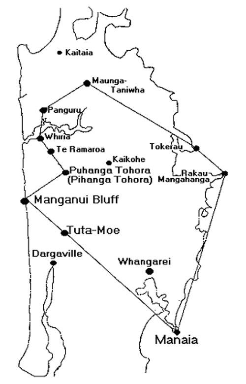
From PUHANGA TOHORA look toward TE RAMAROA (PIHANGA TOHORA)
From TE RAMAROA look toward WHIRIA
The seat of our war-like prowess
The ancestral line of RAHIRI
From WHIRIA look toward PANGURU - to PAPATA
To the thickly growing trees which extend to
the western sea
From PANGURU and PAPATA toward MAUNGA-TANIWHA
From MAUNGA-TANIWHA look toward TOKERAU (Bay of Islands)
From TOKERAU to RAKAU-MANGAMANGA (Cape Brett)
From RAKAU-MANGAMANGA to MANAIA (Whangarei Head)
From MANAIA to TUTA-MOE
From TUTA-MOE to MANGANUI BLUFF
From MANGANUI look toward PUHANGA TOHORA
This is the house of NGA-PUHI
An ancient song preserved by Nga-Puhi, handed down in oral tradition from the Patu-paiarehe who established marked alignment systems and purpose built trigs across Northland, many of which survive to this day. The alignment systems are a combination of erected obelisk stones, boulder cairns and huge tor mounds, orientating onto the highest mountain tops.
Why did they design this sequence to duplicate the star pattern of the Hyades in the constellation of Taurus?
Nga-Puhi oral traditions also mention a linking alignment running from atop Maunganui Bluff (mentioned in the ancient song) to Mount Taranaki (245.57-miles distant at an azimuth angle of 354.15-degrees..which was, undoubtedly, read as 354.375 in mnemonic reference to the 354.375-days in the lunar year).
The distant mountain (Taranaki) could be seen "out to sea" on a clear day, either by direct sight or due to it's reflection onto clouds. Oral traditions state that where the line from Maunganui Bluff crossed the land at Taranaki en route to the mountain, it traversed the region of an important "School of Learning". This reference is, undoubtedly, to "Koru PA"* (a huge stone enclosure with its own "standing stone circle and obelisk alignment systems), which functioned in the capacity of an "open air university"
NB: The line runs very closeby @ 2.7 miles east of the Koru PA observatory hubstone.
In dealing with markers identified in this series of articles, please consider the following:
An alignment running from atop Maunganui Bluff in Northland to Mt Edgecumbe at Kawerau will pass directly over the cluster of huge concretion boulders at Silverdale. These pearl-like boulders were purpose placed as component markers of another alignment that traversed the Auckland Isthmus to Mount William and then to Pukemore Hill at Huntly.
A line extending from Pukemore Hill to Mount Cook in New Zealand's South Island will pass directly over Koru PA in Taranaki.
A line extending from Maunganui Bluff to Te Mata Peak in Havelock North, Hawkes Bay will pass through Otuparae Peninsula, where there is / was an ancient marker mound erected, complete with standing stones (unless the developer's bulldozer has already eradicated it).
The ancient Ngati-Hotu people were vanquished from Hawkes Bay by the incoming warriors and the Ngati-Taniwha iwi of Hawkes Bay are progeny of the earlier Ngati-Hotu people who fled to the inland country of Taupo and Rotorua. They were later annihilated by the Maori warriors who followed them into these districts and hunted them to near extinction.
The ancient Patu-paiarehe people mapped the entirety of their country thousands of years ago and preserved knowledge of the alignments in song or cadence rhythm chants, which came into the possession of those who later conquered and absorbed these early tangata-whenua or taniwha races. The songs of Waitaha.
MIXTURE OF WAIATA – RETUN HOME MY PEOPLE
https://www.youtube.com/watch?v=2XlgKPF8SBc&list=RD2XlgKPF8SBc&start_radio=1&t=71


